Geology

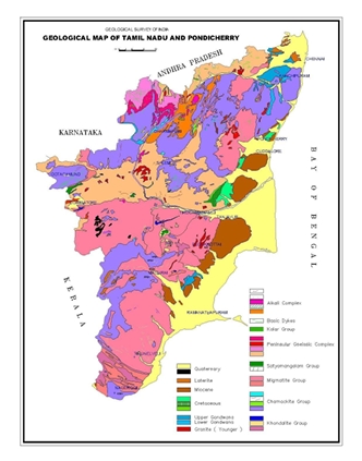
Crystalline rocks of Archaean to late Proterozoic age occupy over 80% of the area of the Tamilnadu, while the rest is covered by Phanerozoic sedimentary rocks mainly along the coastal belt and in a few inland River valleys. The hard rock terrain comprises predominantly of Charnockite and Khondalite groups and their migmatitic derivatives, supracrustal sequences of Sathyamangalam and Kolar groups and Peninsular Gneissic Complex (Bhavani Group), intruded by ultramafic-mafic complexes, basic dykes, granites and syenites. The sedimentary rocks of the coastal belt include fluviatile, fluvio-marine and marine sequences, such as Gondwana Supergroup (Carboniferous to Permian and Upper Jurassic to Lower Cretaceous), marine sediments of Cauvery basin (Lower Cretaceous to Paleogene), Cuddalore /Panambarai Formation (Mio-Pliocene) and sediments of Quaternary and Recent age.

Company Statistics Analysis

Great Achievement For Insurance

8563 +

Saticfied Custimer

2630 +

Experience Members

100 %

Satisfaction Rate

25 +

Years Experience

963 +

Awards Winning

Popular Clients

We’ve 1520+ Global Premium Clients

The Southern Granulite Terrain (SGT) of India, covering the states of Tamil Nadu and Kerala and the marginal zones of Southern Karnataka, was earlier considered to be the southern extension of the Granite-Greenstone terrain of Dharwar Craton exposed at a deeper tectonic level. This concept was based on the observation that the grade of metamorphism gradually increases from north to south. Geochronological and isotopic studies have brought to light that the southern part of the SGT lying south of Palghat Cauvery Lineament (PCL) has a geological history distinctly different from the Dharwar Craton. These studies have shown that the terrain lying north of PCL shows crustal growth during the period from 3400 to 2500 Ma. In contrast, crustal growth in the terrain south of PCL is considered to have taken place predominantly during Post Archaean times, as constrained by Nd model ages (Harris et al., 1994).

This terrain might have witnessed several cycles of metamorphism, the most pervasive being the 550Ma Pan-African granulite facies event as constrained by various isotopic systematics (Unnikrishnan Warrier et al.,1995b; Jayananda et al., 1995, Bartlett et al., 1995). In view of the contrasting geological history recorded by the terrains north and south of PCL, the SGT has been divided into the northern Archaean Craton (Dharwar Craton) and the southern Proterozoic ( Pandyan) Mobile Belt (GSI, 1994) with the PCL marking the boundary between them. Subsequent work by Ghosh et.al (1998) has shown that the Archaean terrain continues south of PCL atleast upto the northern margin of Kodaikkanal massif and according to them Karur-Kambam- Painavu-Thrissur (KKPT) shear-zone marks the boundary between the Dharwar Craton and the Proterozoic Mobile Belt. Geological map of Tamilnadu and Puducherry

GENERAL PROFILE OF THE DISTRICT

The rocks of the district belong mainly to Archaean age, except for- a narrow girdle along the coast in the southwest and south, occupied by sediments of Tertiary and Quaternary ages, respectively. Rocks of Eastern Ghats Supergroup of Archaean age include three divisions, viz, khondalite, Charnockite and migmatite. The Khondalite Group comprises garnet-biotite-sillimariite ± graphite, with thin bands and lenses of quartzite, calc granulite and crystalline limestone. The Charnockite litho unit of the Charnockite Group is well exposed in the southern and southwestern parts of the district, occurring mainly as concordant bands and lenses of variable dimension, associated with Khondalite Group of rocks. The migmatite complex comprises garnet biotite gneiss, garnetiferous quartzofeldspathic gneiss and quartzofelspathic granolites.
Cuddalore Formation of Mio-Pliocene age (correlatable with Warkalli/ Quilon beds of Kerala), comprising calcareous sandstone and Limestone. Limestone is exposed as thin capplngs southwest of Kuzhitura nearer to the coast, bordering Kerala State. Quaternary sediments of fluvial, fluviomarine, aeolian and marine origin occupy a width of 3 to 5 km. all along the southern part of the district, adjacent to coast.
The basement of the area consists of Charnockite, Granite Gneiss, Leptinite, Leptinitic Gneiss, Peninsular Gneiss, Laterite, Warkalli Sandstone, Variegated clay, river alluvium, etc. Two types of Aeolian deposits in the South Travancore, the red sands forming the Teris and white sands forming – the coastal dunes. The geological formations represented in Kanniyakumari district are Archaean metamorphic rocks, Warkalli beds considered Tertiary in age, and two types of blown sands consisting of the red teris (older) and the white coast dunes. Archaean gneisses are by far the most dominant rocks in the area and form the lofty 87 ridges of the Western Ghats, which separate Kanniyakumari from Tirunelveli district. In the low flat area lying between the Western Ghats and the Arabian Sea, the gneisses are very much reduced by erosion and appear as subdued hills. The terrain comprises largely of Precambrian crystalline rocks of Charnockites, Khondalites and Migmatitic gneisses. Beach deposits are derived from the adjacent hinterlands mainly from Charnockites, Khondalites, Biotite gneisses. The topography is mild with an elevation not exceeding 60 m at places in the coastal belt in which crystalline rocks are highly weathered to laterite (GSI, 1999).
The basementrocks are overlain by red soil, lateritic soil, clayed soil, river alluvium and coastal alluvium, black, red and red sandy soils of thickness ranging from 1 to 1.5 m in most places. The area is underlain by the peninsular gneissic terrain of India. Sediments of Miocene were also deposited and identified as the Warkalli sandstones. Also, the sands of recent origin are noticed along the coast. In general, according to the GSI, the geological formations in the study area comprises of unconsolidated sandy formation of different depositional environment belonging to quaternary age. The alluvial deposits are comprised of interlayer clay, silt, sand, gravel and pebble beds. Borehole lithology depicts that the aquifer material comprises of fine to coarse grain sand, sandy clay, clayed sand and small patches of clay occurring as lenses. The clay that exists as thin lenses or small patches was mostly deposited in fluvial and shallow marine environments. These formations overlie the Charnockites of Archean age, Charnockites existing below this formation function as impermeable strata or bed rock (Perumal et al., 2008). Lateral deposits or bay deposits of sand, Zircon, Rutile, Ilmenite and garnet minerals are very common phenomena along the entire coast of Kanniyakumari. Near Manavalakurichi, monazite is deposited (Chacko, 1966). Bulk of the gneisses in the southern part of Tamil Nadu is made up of garnet-biotite gneiss and garnetiferous quartzo-feldspathic gneiss representing the migmatised and retrograded equivalents of Charnockite and Khondalite groups (Narayanaswamy and Purnalakshmi, 1967, Narayanaswamy 1971).